Showing posts with label hazard. Show all posts

Sunday, September 28, 2025

The Wild Side of Japan


Beyond the neon skylines, crowded subways, and hi-tech innovations lies another Japan – a wilder world of mountains, forests, and rice paddies that reveal the country’s deep relationship with nature.


The hills are shaped like traffic cones, except that they’re green. Many of them reach up to over 1,000 meters; the tallest ones nearly 3,000 meters. They stand on both sides of the road – Akita Expressway – blocking any view beyond them except for the sky, which that day was overcast. The forested slopes look virtually impenetrable. There are signs warning of mountain goats, tanuki-raccoon dogs – and bears – along the roadside.

Tohoku, consisting of the northern prefectures on the main island of Honshu, has been called the wild side of Japan. If Japan conjures up images of avant-garde high-rises, hi-tech attractions, and people in dark suits or outrageous anime costumes rushing at subway stations, then you should visit Tohoku. It is another world up here.

We were speeding through the mountains in Kikuchi-san’s Daihatsu Cocoa overtaking many larger vehicles as she pushed the little car to 120 kph. Mami, which is her name, is a hotelier and restaurateur in Iwate and a dear old friend of my wife Yoko. She was taking us from their mutual hometown of Oshu to Akita City in the adjacent prefecture with the same name. The road cut across the north-south mountain range that forms the backbone of Honshu, from Iwate Prefecture in the east to Akita Prefecture in the west, from the Pacific ocean to the Sea of Japan coast. Cutting through the mountains can be taken literally: there are about ten tunnels, most of them short but a few about 2.5 km long. Altogether, one spends more than 10 km driving under the huge mountain masses. What an engineering feat it has been to construct these tunnels!

In between, the road rises to higher ground and occasional bridges cross fertile valleys in the shadow of the steep mountains. These valleys are intensively utilized for farming. Small clusters of farmhouses are surrounded by green rice paddies.
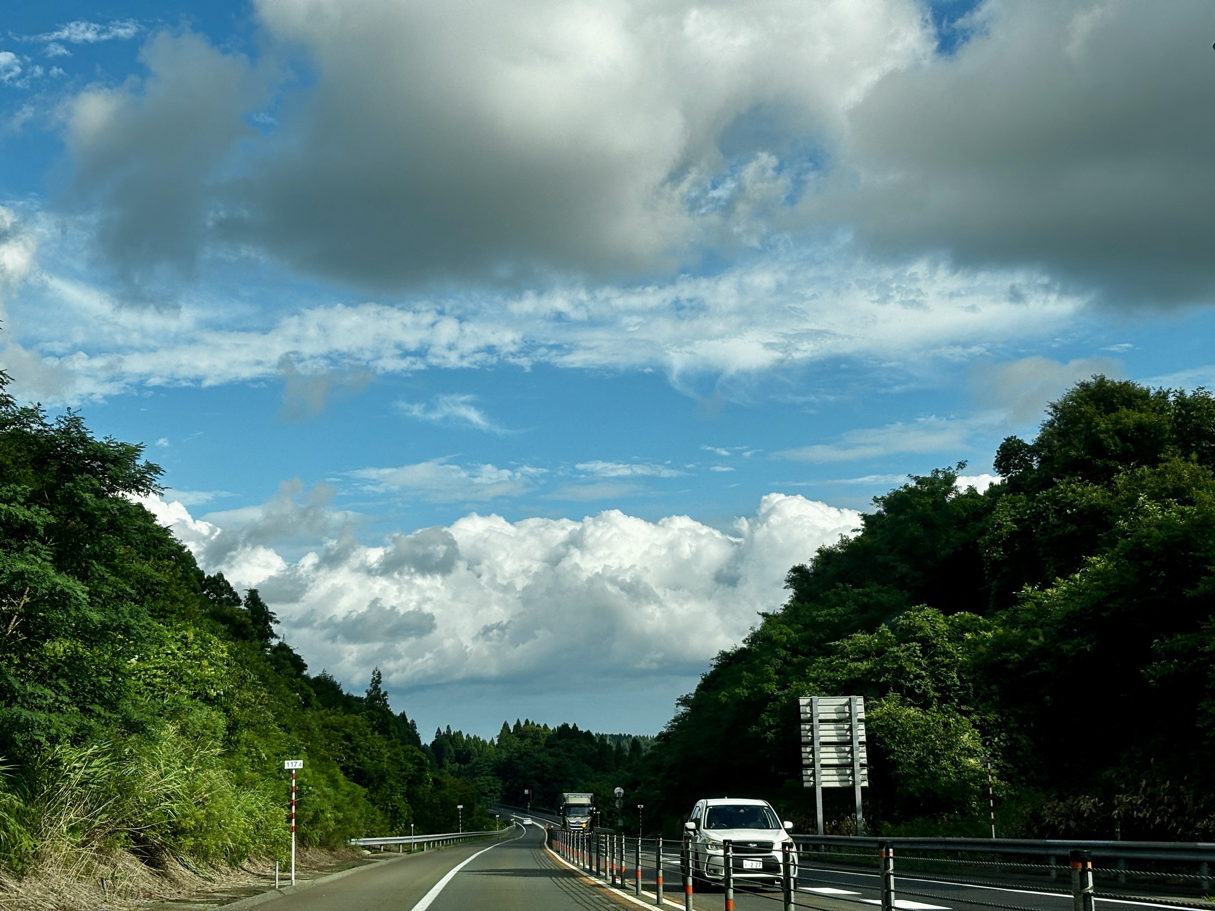
Akita Expressway cuts east to west through the mountains (photo by author).

Rice is the staple in Japan. But it is also more than just food, as the anthropologist Emiko Tierney Ohnuki explains in her book, Rice as Self: “As a metaphor of self, rice paddies are our ancestral land, our village, our region, and ultimately, our land, Japan. They also represent our pristine past before modernity and foreign influences contaminated it” (p. 10). Later she explains, “The notion that each rice grain has a soul and that rice is alive in the hull are fundamental to the meanings assigned to rice in Japanese culture…” (p. 55). The rice paddies prevail even as the countryside empties of people and the farming population ages. This phenomenon also explains the widespread resistance to foreign rice by Japanese consumers, even as rice prices have soared this year and been a major contributor to rising inflation.

Tohoku, with its relatively cold climate, has experienced several rice famines in the recorded history, many of them linked to natural disasters, such as cooling climate after volcanic eruptions. Latest in 1934, the rice crop in Iwate failed due to cold weather, causing many poor farm families to send their children to Tokyo and beyond as laborers, or to work in the water trade, or to join the military, all of which contributed to the pre-war unrest. In better times, Tohoku rice is arguably the best in the world, thanks to the clean environment and water.

Japan’s environmental history is at best checkered. The case of mercury poisoning in Minamata on the southwestern island of Kyushu starting in the late 1950s is perhaps the most famous incident of industrial pollution with dramatic consequences to people’s health. But there were plenty of others where the environment and human health were sacrificed to the altar of progress in post-war Japan, such as the Itai-Itai disease caused by cadmium poisoning discovered in 1967 or the PCB poisoning in and around Kitakyushu the year after. Opposition to industrial pollution was silenced, communities divided, and victims shunned, as the country focused on rebuilding and getting rich at any cost.

Since those years, much has been done to improve the environment. Environmental consciousness is high: practically no one litters, recycling is religiously practiced, and the cities are clean. Air and water pollution are now controlled. The largest urban conglomerations – Tokyo, Yokohama, Osaka, Kobe, Kyoto – are concentrated in the Central and Western Kanto and Kansai areas.

The Japanese culture has been largely based on the desire to control nature. This has its traditional expression in Japanese gardens in which nature has been forced into beautiful, but artificial depictions of, well, idealized nature. The tortured, but gorgeous bonsai trees are another example. For many Japanese, nature is at its most beautiful when it is well regimented.

Another factor playing into the tendency to control nature is the prevalence of natural hazards. Japan consists of a chain of volcanic islands in the middle of the largest ocean of the world, the Pacific. The country is prone to earthquakes that happen daily (although larger ones are of course rarer). Despite its name, the ocean frequently acts in ways anything but pacific, sending typhoons and tsunamis to the coasts. The eruption of the iconic volcano, Mt. Fuji, is long overdue. If a natural hazard exists, Japan is bound to have it in quantities. Consequently, Japan is also the best prepared nation towards natural hazards: even massive earthquakes tend to have relatively few victims.

There are exceptions, the most prominent one in recent history being the earthquake that hit Tohoku on the Pacific side on March 11, 2011. The 9.1 magnitude earthquake and the ensuing tsunami flattened out much of the Sanriku coastal zone in Miyagi and Iwate prefectures and killed almost 20,000 people. The tsunami also caused the meltdown of the Fukushima nuclear power plant resulting in the worst nuclear accident in human history, barring the Chernobyl accident in current-day Ukraine in 1986.

Up in in the mountains between Iwate and Akita, nature is largely unspoiled thanks to a low density of human population, little urbanization and even less industry. That in itself is largely the result of the mountainous topography, the harsh winters, and the relatively short growing season. Yet, virtually all flat valleys are under cultivation.

The topography is also what has saved Japan’s forests. This is one of the most forested countries in the world outside of the tropics, with 67% of land area covered in forests. Japan in the post-World War II years extensively replanted forests, with species like sugi and the Japanese cypress. According to environmental historian Catherine Knight, about 40% of Japan’s forests are currently man-made plantations, not naturally occurring ecosystems.

The forests would most certainly have been decimated had it been easier and more economical to exploit them. Instead, it is said that Japan has outsourced deforestation, especially to Southeast Asia where its companies have long maintained logging operations thereby saving the forests on the home islands.

What is evident even up here in Tohoku is the careful management of natural hazards and nature itself. Mountainsides where roads cross them are protected by engineering works to prevent landslides, which can be caused by earthquakes or just erosion of the slopes.

Japan has been referred to as the “construction state.” The Ministry of Construction and the numerous big and small companies operating in the sector wield significant power. They provide substantial employment and spend remarkable amounts of money as they fix the real and sometimes self-created problems.

In the decades following World War II, most rivers in Japan, notably near urban centers on the Kanto Plain, were straightened and channelized in concrete to control natural flow and meandering. Contrary to expectations, however, these works meant for flood control often had the opposite effect, while also harming ecosystems along the rivers. The government, to a degree, recognized the mistakes and mended its ways, leading the River Bureau of the Ministry of Land, Infrastructure, Transport and Tourism to reverse engineer riverine habitats since the 1990s. Today, Tohoku’s largest river – and to me the dearest – Kitakami-gawa flows quite freely from its origins at Mt. Nanashigure to the Pacific Ocean.

But the time of the construction follies is not over. Following the March 2011 earthquake and tsunami, which destroyed virtually all small fishing ports on the Sanriku coast, many survivors left. Especially younger people moved to Sendai and other cities. Few of the refugees had any intention to return to the coast. Given this and the fact that the tsunami threat will not disappear, to me the sensible thing would have been to develop the coastline to an area for nature and recreation. Instead, the government has invested tremendous amounts of resources to massive earth moving and construction works to raise the coastline, in the process destroying much of the nature literally flattening hills. This for a handful of mostly old people who may return. That just demonstrates the natural tendency of the authorities and the construction industry to find an engineering solution to any problem.

Driving through the central mountains, however, these problems are far away. Yet, just like Sanriku coast, the countryside in the remote sparsely populated areas is further emptying. Most of the young people have moved to cities and the small farmers have few heirs to take over their plots (although there is a small back-to-the-land movement driving some younger urbanites to a more organic lifestyle in the rural areas). One might think that depopulation might lead to rewilding of the land – a popular concept in some parts of Europe – and there may be some benefits to the wildlife. However, the traditional farming system – satoyama – is surprisingly well adapted to the natural ecosystem. The rice paddies themself are ecotopes of their own, with a vibrant fauna and flora. There are studies that suggest that losing this agricultural landscape is a threat to the biodiversity that has evolved in them.

Japan is making measurable progress on climate and environmental fronts and is rolling out a nature-positive economy strategy, which includes the “30 by 30” conservation target, aiming to protect 30% of land and marine regions by 2030. Yet, challenges remain, not least as global temperatures rise affecting climate and weather in this island nation.

Tohoku’s rugged landscapes remind us that Japan’s story is not just one of futuristic glory and control of the environment, but of coexistence with nature, which offers lessons in resilience and balance that Japan, and the world, will need more than ever.


Thursday, July 10, 2025

Is another massive tsunami imminent in Japan?

Fourteen years ago, Japan was devastated by one of the deadliest tsunamis in modern history. Now a prophetic manga is fueling anxiety of a repeat. Could such a calamity occur soon again?

On Friday, March 11, 2011, at 14:46 hrs, disaster struck Japan. One of the largest earthquakes—officially the Great East Japan Earthquake—on record (magnitude 9.0) occurred just off the northeast Pacific coast of the main island of Honshu. The shaking lasted for a full five minutes—a terrifyingly long time when one entirely loses orientation, may not be able to stand up, with everything falling around you, walls and houses crumbling, the rumble of the earth drowning all other sounds—triggering a massive tsunami. Because the epicenter was so close to the coast, there was hardly any warning or time to evacuate. The first waves reached the Sanriku coast in the Miyagi and Iwate Prefectures within ten minutes, completely overrunning the towns and ports leaving total destruction in their wake. Up to 18,500 people perished. The tsunami also caused the meltdown of the nuclear power plant in Fukushima, Miyagi Prefecture, the worst nuclear accident ever to hit Japan and the worst in the world only after Chernobyl.

Now some people, are again fearful to visit Japan. This is because of a manga comic, published in 1999 and re-released in 2021, warns of a catastrophe hitting Japan in July 2025. The only reason why this comic might scare people off is that it originally predicted, correctly it turned out, a major disaster in Japan in March 2011. The Future I Saw, by the artist Ryo Tatsuki, imagines a massive tsunami caused by a rupture in the undersea fault line between the Philippine and Eurasian plates. As a consequence, the number of tourists, especially from China and Hong Kong, has dropped significantly and some people have decided to postpone their trips to Japan. Tatsuki herself says that she is no prophet.

The scenario itself is not entirely unrealistic. Tsunamis are triggered by undersea events, most often large earthquakes at fault zones, but sometimes by volcanic eruptions or massive landslides deep in the ocean. The Pacific Rim where Japan is located is seismically highly active. The Sanriku Tsunami was the fifth most deadly in the past two centuries or so. The deadliest of all was the Indian Ocean Tsunami on Boxing Day of 2004 when an estimated 230,000-280,000 people perished in half a dozen countries surrounding the Indian Ocean. This was the second time the Sanriku coast was devastated by a tsunami: on June 15, 1896, another tsunami killed some 22,000 people in the same area with waves reaching the height of 30 meters.

Tsunamis are so deadly because of the massive amounts of water and the speed at which they travel. In deep water, the waves remain low but they spread fast in all directions from the epicenter. Tsunami waves have been measured to move at 800 km/h. As they approach shallower coastal waters they slow down, condense, and rise to frightening heights.

This is what destroyed so much of the Sanriku coast. Kesennuma, a port in Miyagi, was gone. I have visited the town both before and after the disaster. First the tsunami swept across the entire low-lying valley. When it receded, fires that ensued as gas pipelines were destroyed finished the job burning down the entire old wooden town. Kesennuma port had been the center of the Pacific shark fisheries just because of the shape of its natural harbor. Now this same geographic advantage had provided the tsunami with a perfect entrance to the harbor bowl allowing the water to rise unhindered into the town.

Tohoku’s largest city, Sendai, situated on higher ground and away from the sea was largely spared from major damage. The city airport closer to the coast was not so lucky. Cameras showed the massive wave sweeping slowly across the runways. Large jet planes floated away like toy models. Aerial shots from the close by mountain areas showed huge liquefaction of the soil, again in slow motion, wiping away entire villages, houses crumbling and washing down the slopes into the sea. 

So what are the chances that such a disaster repeats itself in the near future, if not later this month? It is impossible to give a precise answer to that question. Statistically, major tsunamis globally take place about twice in a decade. The likelihood of one striking a specific major urban is low but it is plausible that one of the major cities around the Pacific Ring of Fire will be struck by a large tsunami in the coming few decades.

The cities most at risk include the Tokyo-Yokohama conurbation, the largest city complex in the world with over 40 million inhabitants. This is also Japan’s economic heart, so a major disaster there would be highly destructive for the country and would disrupt the entire world economy.

Other likely targets include Manila and Jakarta on the Asian side, and Lima and Santiago de Chile in South America, as well as Los Angeles and San Francisco in California. Honolulu in the middle of the Ring of Fire is also vulnerable. In fact, all of these cities have in the past experienced disruptive earthquakes and tsunamis.

Indonesia and its capital Jakarta are particularly at risk from a repeat of an event like the 2004 earthquake and tsunami. Another risk is posed by the active volcano, Krakatoa. Its violent eruption caused a massive tsunami on August 27, 1883. It destroyed two-thirds of the island and killed some 36,000 people, making it the second deadliest event in recorded history.

Hawai’i due to its location has experienced three tsunamis claiming lives in the past eight decades. The worst one was on April 1, 1946, when a 8.6 magnitude earthquake in the Aleutian Islands sent a tsunami racing across the ocean. It destroyed most of Hilo on the Big Island, killing 159 people. As the earthquake that instigated the tsunami took place in Alaska thousands of kilometers northeast of Hawai’I, no one was prepared when the huge waves washed into the islands in the middle of the Pacific Ocean.

When the 9.5 magnitude—the strongest ever recorded—earthquake hit Chile on May 23, 1960, Hilo, 10,000 km away from the epicenter, was again collateral damage and 63 people died there (the range of the casualties overall varies significantly, from 1,000 to 6,000). On November 29, 1979, a local 7.7 magnitude earthquake shook the Big Island causing two deaths. Such a locally generated tsunami gives hardly any warning time for people to escape.

All of the cities exposed to high tsunami risk are constantly monitoring the situation. Japan, with its multi-hazard risk and frequent earthquakes (in fact, a 5.5 magnitude earthquake shook the southwestern Kagoshima Prefecture while I am writing this on the 3rd of July), is arguably the best prepared country in the world. In this, it is helped by its advanced technologies and well-educated, self-disciplined population. Japan employs a national earthquake and tsunami early warning system operated by the Japan Meteorological Agency. It informs people of impending danger through sirens and phone alerts. It has recently deployed drones on the sea in front of popular beaches for tsunami detection. Detailed evacuation maps are maintained by local governments down to the neighborhood level.

Furthermore, millions of people in the country participates in drills and education sessions. September 1st is the National Disaster Prevention Day, with the date commemorating the Great Kantō Earthquake that destroyed Tokyo in 1923.

Scientists in Japan give an 80 percent chance for a mega-quake taking place along the Nankai Trough in the coming 30 years. This revised assessment has led the authorities to require municipalities and businesses to enhance their preparedness plans, to strengthen building earthquake resistance, stockpile food and other necessities, and to update evacuation plans.

Earthquakes and tsunamis cannot be predicted with any degree of certainty. A major event is certain to cause significant damage to infrastructure and the economy. The death of thousands of people in such eventuality is unavoidable. The best we can do is to be aware of the risks and be well prepared. That is our best chance of saving lives.

[Originally published on https://juhauitto.substack.com on July 4, 2025.]

Saturday, May 23, 2020

Summer of Hazards: Pandemic, hurricanes and other dangeers

We’re in for a wild ride this summer if the early indications are to be believed. The COVID-19 pandemic is not showing any signs of waning, irrespective of how tired people are getting to shelter in space and despite wishful thinking by politicians. Unlike in Asia and Europe where the numbers of infections are actually going down rapidly, the US pandemic is still growing. Just in one day, May 21st, there were more than 24,000 new cases reported in the United States. Only the geographical patterns are shifting.

On top of the pandemic we are seeing other threats creeping up on us, many of them also related to the global environment. I say also, as it is a scientific fact that the root causes of this pandemic—like the ones before it and others to come after we have cleared this one—lie in how we interact with and abuse the natural environment. The virus causing COVID-19 is zoonotic, meaning it originated in animals and jumped over to humans. Such spillovers have gotten more frequent as our contacts with both domesticated and wild animals have intensified and as our activities have spread deeper into previously undisturbed environments through urban sprawl, agricultural expansion, road building, logging, mining and other disruptive actions.

While weather is notoriously hard to predict even with the highly sophisticated computer simulations using big data that today are used for the purpose, virtually all major organizations engaged in such predictions agree that the 2020 Atlantic hurricane season will be way more active than in an average year.

NOAA, the National Oceanic and Atmospheric Administration, released its annual forecast on Thursday, May 21, predicting there will be 13-19 named storms in the season from June 1 to November 30, as opposed to an average of 12 such storms. Out of these, NOAA predicts 6-10 may become hurricanes, compared with an average year’s 6 hurricanes. Three to six out of these could further develop into major hurricanes—or category 3-5 storms—with wind speeds of more than 111 miles per hour (178 km/h). Of course, we do not know how many of these will actually hit continental USA, but even one major hurricane can do terrible damage.

Tropical cyclones—types of storms that include hurricanes in the Atlantic and typhoons in the Pacific—are named in order to easily distinguish between them as in busy times more than one may be active. Names are usually given to storms that reach sustained wind speeds of at least 40 miles per hour (65 km/h). Although the season only officially starts on June 1 there already was one—Arthur—that formed as early as May 16 off the Florida coast. While Arthur veered off to the open sea having brought only moderate rain and wind to the southeastern coast, its early appearance can be seen as a harbinger of things to come.

The increased hurricane activity is inevitably linked to climate change. It is statistically impossible to link any particular hurricane or storm to climate change. However, at a larger scale and over longer timeframes scientists are able to model how the warming trends increase the likelihood of hurricanes in terms of their frequency and intensity. One of the key drivers of stronger hurricane activity is the warmer than normal sea surface temperatures in the tropical parts of the Atlantic and the Caribbean. The primary reason for this is the warming of global temperatures caused first and foremost by the burning of fossil fuels for energy and transportation. Cutting down forests to make way for agriculture and human settlements, as well as methane emissions from cattle ranching are other huge culprits.

A warming climate gives a double whammy to coastal communities. It brings more frequent and larger storms, and it causes sea levels to rise as the warming water expands. Places like the Outer Banks off the North Carolina coast will bear the brunt of these changes, but in the medium term the entire Eastern Seaboard and its large cities from Miami to New York are vulnerable.

Further inland, this past week we saw two catastrophic dam failures in the Tittabawassee River basin in central Michigan, forcing the evacuation of 10,000 residents from their homes in the midst of the pandemic. This is another climate-related disaster. The dams were breached because of excessive rainfall upstream. The engineers described this as a once in a 500 years event. However, such standards are rapidly becoming obsolete with rainfall and other weather patterns changing as a result of global warming, bringing increased rains to some places and droughts to others.

A natural hazard only becomes a disaster when it meets frail infrastructure. The broken dams failed because they were in poor shape. CBS News reported on Thursday (May 21, 2020) that the Federal Energy Regulatory Commission, FERC, had in 2018 revoked the license from Boyce Hydro Power, the company that operated one of the failed dams, the Edenville Dam, citing the company’s “long history of non-compliance” related to the dam’s ability to cope with a major flood.

This is by no means a unique situation amongst America’s 91,000 dams. As reported by the Guardian (May 23, 2020), the federal government’s National Inventory of Dams identifies over 15,000 dams in the country that would likely result in deaths should they fail. According to the inventory, at least 2,300 of them are in poor shape. The average age of the US dams is 57 years (the Edenville Dam was built in 1924) and many are hardly maintained. Seventy percent of the nation’s dams are under the jurisdiction of state governments and another 5 percent watched over by the federal government, but one quarter have no governmental oversight at all. Even in cases where regulatory agencies point out to deficiencies, the operators often fail to follow up because of high costs associated with repairs and upgrades.

The dams, of course, are but one aspect of America’s infrastructure that has been rendered vulnerable due to decades of lacking investment in maintenance. Powerlines, bridges and other transportation infrastructure will be equally susceptible to damage and disruption from floods, storms, landslides, erosion and other events that are likely to increase as the climate changes and we continue cutting down forests and building in unsafe places.

In the highly politically polarized environment of the USA today, there is a certain irony in how these multiple hazards manifest themselves geographically. One of the reasons why it has been easy for protesters to dismiss the pandemic thus far is that it has mostly ravaged big cities like New York and San Francisco. These cities are also liberal bastions and epitomize the degenerate coastal elites in the minds of many in the heartland. This has allowed people to believe in conspiracy theories that the pandemic is really just an invention of those who want to foil President Trump’s re-election bid or force vaccinations upon people or just generally destroy the American way of life. This is now changing as the pandemic spreads to smaller cities and rural areas, when states are prematurely opening up their economies. Amongst the states with the highest increases in infection rates are now Tennessee, Louisiana, Texas, North Carolina and Michigan.

Some of these are the same places that are going to suffer from the other hazards, as is indeed the case of Michigan where the dam breaches and flooding disaster added to the pandemic woes. The hurricanes, naturally, are mostly going to pound the states on the Atlantic shore. The hardest hit will be those in the south, from Florida to North Carolina—including its barrier islands—places where beach vacationing plays a central part in lifestyle and economy.

Unfortunately, too, as we’ve seen in the past, the first ones to be hit by hurricanes are the Caribbean islands whose economies are so totally dependent on tourism. In September 2017, Puerto Rico was devastated by Hurricane Maria whose effects are still acutely felt on the island. The storm caused as much as $95 billion in damages, wiped out 80 percent of the island’s agricultural crop, and has since caused more than 130,000 residents to leave the island. It has taken months to restore reliable power and water to households. This spring, the pandemic has halted tourism to Puerto Rico as well as other islands placing a further strain on the recovery and people’s lives.

It is of course not only the islands and coastal areas that are exposed to such multiple hazards. Dams and other vulnerable infrastructure exist everywhere in the country. Like always, the people who suffer most are the ones who have the least resources to fall back on when they lose their property, livelihoods or health. They also tend to be the ones living in locations most exposed to both natural and manmade hazards. COVID-19 has demonstrated clearly the inequalities at play, and many of them have a geographical dimension. But that is a story for another piece.

Now, as many states are reopening and so many people can’t wait to get their lives back, it is not an easy message to deliver that the summer that is so full of hope may end up being full of hazards instead. Medical experts and epidemiologists all seem to agree that getting back to normal, enjoying the parties, the barbecues, the beaches that go with a good summer, will almost inevitably result in second waves of the pandemic in places where it now has started to wane—and to full blooms in places that have yet to be hit by it. When at the same time we get hit by hurricanes and other natural calamities, coping only gets that much harder. We can of course get through it, if we decide to behave responsible and to support each other. We also need competent public services that can help people and communities in distress. In the longer term, we must get used to the idea that this may be the new normal.

It still isn’t too late to improve our relationship with nature, to become more mindful of how we use natural resources, where and how we build, and how we pollute the atmosphere, land and oceans. We must find ways of more sustainable development that shares the benefits more equally. These are solutions that are absolutely needed but will only start making a difference many years from now. For the immediate future, we need to find effective ways of adapting to climate change and building a society that is more resilient towards shocks, be they pandemics, storms, floods or something that we cannot even imagine at this time. It can be done, but it requires trust: in institutions, in expertise, in science and, not least, in each other.

https://medium.com/@JuhaUitto/summer-of-hazard-pandemic-hurricanes-and-other-dangers-9fc9cb6d4cf8

Tuesday, October 30, 2012

Sandy farewell


Monday, 29 October 2012


On Monday morning New York City is closed down. I’m staying at home as my office, like most others, has been forced shut. Without transportation it would anyway be impossible to get to Manhattan. It doesn’t look too bad outside, though. It’s grey and the rain is falling, but it all looks rather calm. The wind comes in gusts that violently shake the trees outside. Some leaves have already turned yellow and are flying off like wet rags.

By noon the situation is starting to look more serious. According to the reports, the storm has been moving faster than anticipated and therefore has arrived earlier than expected. Its power has intensified. There’s by now no doubt this’ll be the worst storm to hit New York since the 1938 hurricane. The TV shows images from Atlantic City, NJ. The famous boardwalk and the casinos are being pounded by heavy winds and the waves from the open ocean are splashing forcefully onto the shore. I remember my brother has a vacation property on the Brigantine Island not far from Atlantic City. I also remember it faces the ocean. There’s only the sandy beach and a narrow street between the building and the Atlantic. In good weather, the location is lovely.

I correspond with my colleague Chona who lives in New Jersey. She is lamenting the pictures of her beloved Jersey Shore being eaten up by the waves. The TV meteorologist explains how New York City is squeezed in between New Jersey and Long Island, which means that in an Atlantic storm situation like today, the water has only one way to go: inland towards the city via the inlets. Therefore, the storm surge forecast for New York harbour is grim.

The most threatening situation starts unfolding in mid-afternoon on the west side of Manhattan. A crane on a high-rise construction site on the 7th Avenue at 57th Street has collapsed and is hanging upside-down at the height of the 90th floor above the city. There is no way to stabilize it, so it’ll be pure luck if it stays up and doesn’t fly smashing into neighbouring buildings and onto the street.

Around 4 pm Governor Andrew Cuomo holds another press conference flanked by NYFD and other emergency personnel. A troop of National Guardsmen dressed in camouflage uniforms stands guard behind them. There is a life-threatening situation on Fire Island, a thin barrier island off Long Island. Fourteen people who refused to obey the mandatory evacuation order last night had to be rescued today. Having spent some good summer vacation time on the island, I can’t even imagine anyone wanting to face a hurricane on that thin sliver of sand in the Atlantic. In the process a rescue vehicle has been lost. Luckily there were no personnel losses. Cuomo quotes Mayor Michael Bloomberg, who accused people who refused to leave of being selfish, putting others at peril. The emergency chief tells in no uncertain terms that the window to evacuate is rapidly closing. Sandy is now expected to make landfall around 18:00, which will coincide with the peak of the tide coming in. When that happens, it won’t be possible to get out of the islands that surround New York City.


I also correspond with my other colleague Indran who lives high up in one of the high-rises on the East River waterfront in Manhattan. It is Zone A, but the building complex is very solid and the water would anyway never reach that high up, so he had chosen not to evacuate. He and his family moved here from South Africa only earlier this year. They are awed by the storm which they can observe through rattling windows from a vantage point tens of stories above sea level.

Our building is faring well, too. We stay in our warm apartment and enjoy the food we stocked up on before the storm: steaks and asparagus for lunch, followed by coffee ice cream; grilled chicken and salad for dinner. Do we normally eat this well? Nowa sleeps through much of her first hurricane. I go down to the basement, which looks dry—so far. 

Around the time of the landfall, I venture out briefly to snap these photographs. From the balcony the southwestern sky looks menacing. On the street side, the large trees are bending with the gale force winds. Luckily, the rain remains surprisingly moderate.

In early evening, the communications start to falter. The cable network on which our building depends on for the Internet, TV and telephone landline goes dark. The elevator also becomes unsafe to use. We’re cut off from information and communications. Well almost, as Yoko’s iPhone can still send and receive messages (my older model went blank). Some neighbours in the building report water leaking from their a/c vents. Apparently, water is also starting to gather in the basement.

Around 21:30, Yoko reads on the iPhone that Sandy is no longer a hurricane. The National Hurricane Centre has reclassified it because it “has continued to lose tropical characteristics”—no wonder at these latitudes. It doesn’t mean that its power is waning. Sustained winds of more than 120 km per hour remain. The wind and rain continue late into the night.

Tuesday, 30 October

We survived the storm with minor personal inconvenience. In the morning the winds are still high and there are heavy showers. At the JFK airport, top wind speeds recorded were 127 kph. Our cable service is restored and we never experienced a power outage. Not everyone was equally lucky. The storm left some 7 million people in 11 states and the District of Columbia without power. In New York, power outages are widespread and currently 1.8 million people are without power. In the New York University Langone Medical Centre even the back-up generator system failed. Some 260 patients, including four newborn babies, had to be evacuated.

ConEdison, the power utility, made a statement that this is the biggest storm-related problem in the company’s history. A representative couldn’t give a timetable for fixing the problems but suggested it may take a week to fully restore the service. It's going to be a cold and dark week for those affected. 

The initial reports by the police talk about seven Sandy-related deaths in the city, but there is no information about how these happened. The national death toll from Sandy is currently put at 16. According to news reports, more than 80 homes have burned down to the ground in a fire in Breezy Point, Queens, due to electric fires. One can imagine insurance companies studying the hurricane causes in the policies for loopholes to avoid payment to the home owners. A building in Chelsea collapsed partially because of the wind. The crane in Midtown West is still hanging there, but the situation remains dangerous and the police have evacuated buildings in the neighbourhood.

There is massive flooding around the city. The National Hurricane Centre recorded storm surges of up to 3.8 metres in Kings Point. The storm surge in southern Manhattan’s Battery at 4.3 metres, was the highest ever on record, beating that caused by Hurricane Dana in 1960. In the South Street Seaport waves with a height of 9 metres were measured. Residents on Staten Island report that they have never seen anything like this. Coney Island waterfront is still inaccessible even to eager reporters. Streets look like rivers with cars floating on them. Cars have been crushed under felled trees. One car spontaneously combusted in a fireball, possibly caused by salt water getting into its battery. A huge tanker has washed ashore on Staten Island.

Reports are coming in and are being updated as more information becomes available. The economic impact has not yet been assessed.

The system-wide shutdown of mass transit—both local and long distance trains, subways, buses, ferries—continues. Seven subway tunnels are severely flooded. One can only imagine the hordes of rats sprinting across the debris in the deluge. Apparently MTA had managed to get all subway cars on higher ground in anticipation of the storm, so the trains have been spared damage. MTA calculates it’ll take four days to pump out the water from the tunnels. The rain continues to fall.

It seems that we’ll spend some more time indoors.