Showing posts with label earthquake. Show all posts

Sunday, September 28, 2025

The Wild Side of Japan


Beyond the neon skylines, crowded subways, and hi-tech innovations lies another Japan – a wilder world of mountains, forests, and rice paddies that reveal the country’s deep relationship with nature.


The hills are shaped like traffic cones, except that they’re green. Many of them reach up to over 1,000 meters; the tallest ones nearly 3,000 meters. They stand on both sides of the road – Akita Expressway – blocking any view beyond them except for the sky, which that day was overcast. The forested slopes look virtually impenetrable. There are signs warning of mountain goats, tanuki-raccoon dogs – and bears – along the roadside.

Tohoku, consisting of the northern prefectures on the main island of Honshu, has been called the wild side of Japan. If Japan conjures up images of avant-garde high-rises, hi-tech attractions, and people in dark suits or outrageous anime costumes rushing at subway stations, then you should visit Tohoku. It is another world up here.

We were speeding through the mountains in Kikuchi-san’s Daihatsu Cocoa overtaking many larger vehicles as she pushed the little car to 120 kph. Mami, which is her name, is a hotelier and restaurateur in Iwate and a dear old friend of my wife Yoko. She was taking us from their mutual hometown of Oshu to Akita City in the adjacent prefecture with the same name. The road cut across the north-south mountain range that forms the backbone of Honshu, from Iwate Prefecture in the east to Akita Prefecture in the west, from the Pacific ocean to the Sea of Japan coast. Cutting through the mountains can be taken literally: there are about ten tunnels, most of them short but a few about 2.5 km long. Altogether, one spends more than 10 km driving under the huge mountain masses. What an engineering feat it has been to construct these tunnels!

In between, the road rises to higher ground and occasional bridges cross fertile valleys in the shadow of the steep mountains. These valleys are intensively utilized for farming. Small clusters of farmhouses are surrounded by green rice paddies.
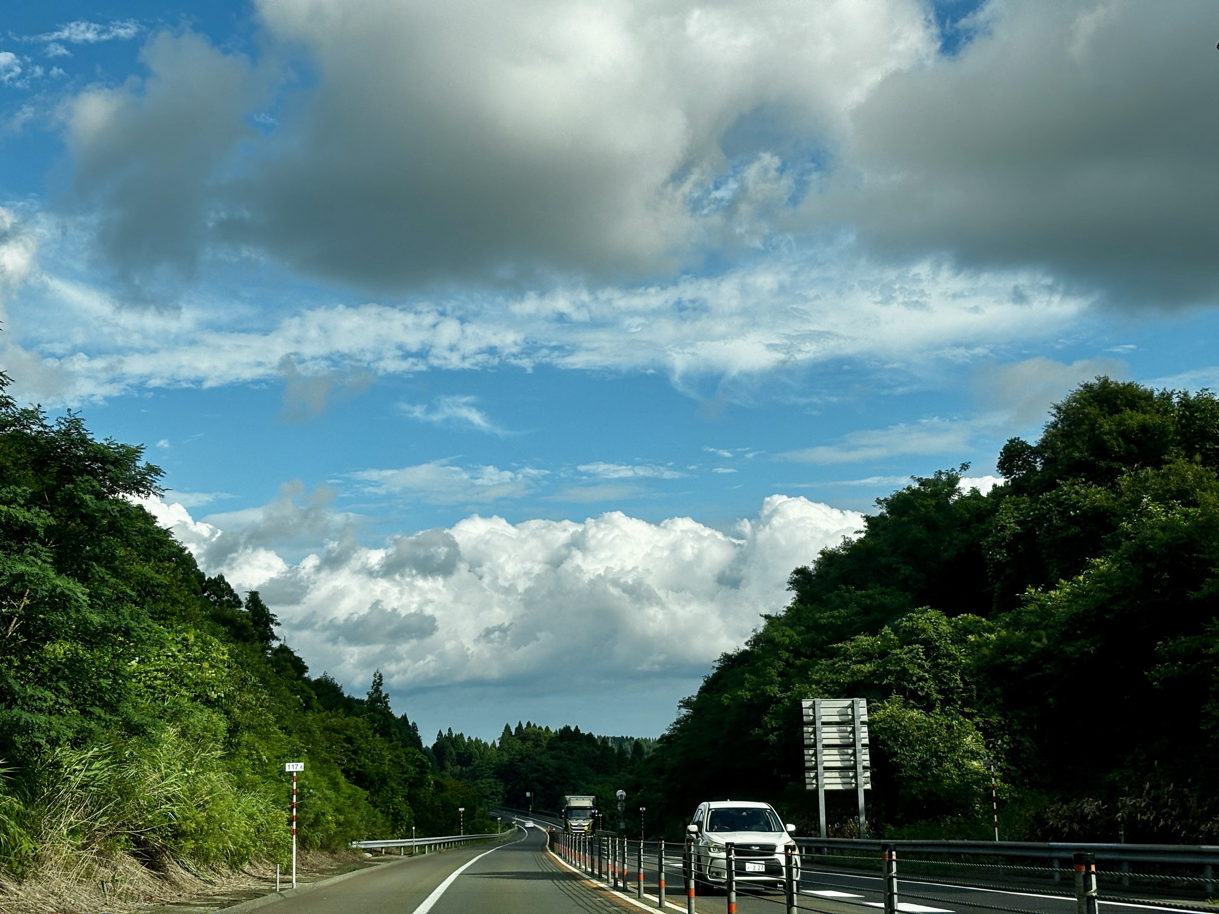
Akita Expressway cuts east to west through the mountains (photo by author).

Rice is the staple in Japan. But it is also more than just food, as the anthropologist Emiko Tierney Ohnuki explains in her book, Rice as Self: “As a metaphor of self, rice paddies are our ancestral land, our village, our region, and ultimately, our land, Japan. They also represent our pristine past before modernity and foreign influences contaminated it” (p. 10). Later she explains, “The notion that each rice grain has a soul and that rice is alive in the hull are fundamental to the meanings assigned to rice in Japanese culture…” (p. 55). The rice paddies prevail even as the countryside empties of people and the farming population ages. This phenomenon also explains the widespread resistance to foreign rice by Japanese consumers, even as rice prices have soared this year and been a major contributor to rising inflation.

Tohoku, with its relatively cold climate, has experienced several rice famines in the recorded history, many of them linked to natural disasters, such as cooling climate after volcanic eruptions. Latest in 1934, the rice crop in Iwate failed due to cold weather, causing many poor farm families to send their children to Tokyo and beyond as laborers, or to work in the water trade, or to join the military, all of which contributed to the pre-war unrest. In better times, Tohoku rice is arguably the best in the world, thanks to the clean environment and water.

Japan’s environmental history is at best checkered. The case of mercury poisoning in Minamata on the southwestern island of Kyushu starting in the late 1950s is perhaps the most famous incident of industrial pollution with dramatic consequences to people’s health. But there were plenty of others where the environment and human health were sacrificed to the altar of progress in post-war Japan, such as the Itai-Itai disease caused by cadmium poisoning discovered in 1967 or the PCB poisoning in and around Kitakyushu the year after. Opposition to industrial pollution was silenced, communities divided, and victims shunned, as the country focused on rebuilding and getting rich at any cost.

Since those years, much has been done to improve the environment. Environmental consciousness is high: practically no one litters, recycling is religiously practiced, and the cities are clean. Air and water pollution are now controlled. The largest urban conglomerations – Tokyo, Yokohama, Osaka, Kobe, Kyoto – are concentrated in the Central and Western Kanto and Kansai areas.

The Japanese culture has been largely based on the desire to control nature. This has its traditional expression in Japanese gardens in which nature has been forced into beautiful, but artificial depictions of, well, idealized nature. The tortured, but gorgeous bonsai trees are another example. For many Japanese, nature is at its most beautiful when it is well regimented.

Another factor playing into the tendency to control nature is the prevalence of natural hazards. Japan consists of a chain of volcanic islands in the middle of the largest ocean of the world, the Pacific. The country is prone to earthquakes that happen daily (although larger ones are of course rarer). Despite its name, the ocean frequently acts in ways anything but pacific, sending typhoons and tsunamis to the coasts. The eruption of the iconic volcano, Mt. Fuji, is long overdue. If a natural hazard exists, Japan is bound to have it in quantities. Consequently, Japan is also the best prepared nation towards natural hazards: even massive earthquakes tend to have relatively few victims.

There are exceptions, the most prominent one in recent history being the earthquake that hit Tohoku on the Pacific side on March 11, 2011. The 9.1 magnitude earthquake and the ensuing tsunami flattened out much of the Sanriku coastal zone in Miyagi and Iwate prefectures and killed almost 20,000 people. The tsunami also caused the meltdown of the Fukushima nuclear power plant resulting in the worst nuclear accident in human history, barring the Chernobyl accident in current-day Ukraine in 1986.

Up in in the mountains between Iwate and Akita, nature is largely unspoiled thanks to a low density of human population, little urbanization and even less industry. That in itself is largely the result of the mountainous topography, the harsh winters, and the relatively short growing season. Yet, virtually all flat valleys are under cultivation.

The topography is also what has saved Japan’s forests. This is one of the most forested countries in the world outside of the tropics, with 67% of land area covered in forests. Japan in the post-World War II years extensively replanted forests, with species like sugi and the Japanese cypress. According to environmental historian Catherine Knight, about 40% of Japan’s forests are currently man-made plantations, not naturally occurring ecosystems.

The forests would most certainly have been decimated had it been easier and more economical to exploit them. Instead, it is said that Japan has outsourced deforestation, especially to Southeast Asia where its companies have long maintained logging operations thereby saving the forests on the home islands.

What is evident even up here in Tohoku is the careful management of natural hazards and nature itself. Mountainsides where roads cross them are protected by engineering works to prevent landslides, which can be caused by earthquakes or just erosion of the slopes.

Japan has been referred to as the “construction state.” The Ministry of Construction and the numerous big and small companies operating in the sector wield significant power. They provide substantial employment and spend remarkable amounts of money as they fix the real and sometimes self-created problems.

In the decades following World War II, most rivers in Japan, notably near urban centers on the Kanto Plain, were straightened and channelized in concrete to control natural flow and meandering. Contrary to expectations, however, these works meant for flood control often had the opposite effect, while also harming ecosystems along the rivers. The government, to a degree, recognized the mistakes and mended its ways, leading the River Bureau of the Ministry of Land, Infrastructure, Transport and Tourism to reverse engineer riverine habitats since the 1990s. Today, Tohoku’s largest river – and to me the dearest – Kitakami-gawa flows quite freely from its origins at Mt. Nanashigure to the Pacific Ocean.

But the time of the construction follies is not over. Following the March 2011 earthquake and tsunami, which destroyed virtually all small fishing ports on the Sanriku coast, many survivors left. Especially younger people moved to Sendai and other cities. Few of the refugees had any intention to return to the coast. Given this and the fact that the tsunami threat will not disappear, to me the sensible thing would have been to develop the coastline to an area for nature and recreation. Instead, the government has invested tremendous amounts of resources to massive earth moving and construction works to raise the coastline, in the process destroying much of the nature literally flattening hills. This for a handful of mostly old people who may return. That just demonstrates the natural tendency of the authorities and the construction industry to find an engineering solution to any problem.

Driving through the central mountains, however, these problems are far away. Yet, just like Sanriku coast, the countryside in the remote sparsely populated areas is further emptying. Most of the young people have moved to cities and the small farmers have few heirs to take over their plots (although there is a small back-to-the-land movement driving some younger urbanites to a more organic lifestyle in the rural areas). One might think that depopulation might lead to rewilding of the land – a popular concept in some parts of Europe – and there may be some benefits to the wildlife. However, the traditional farming system – satoyama – is surprisingly well adapted to the natural ecosystem. The rice paddies themself are ecotopes of their own, with a vibrant fauna and flora. There are studies that suggest that losing this agricultural landscape is a threat to the biodiversity that has evolved in them.

Japan is making measurable progress on climate and environmental fronts and is rolling out a nature-positive economy strategy, which includes the “30 by 30” conservation target, aiming to protect 30% of land and marine regions by 2030. Yet, challenges remain, not least as global temperatures rise affecting climate and weather in this island nation.

Tohoku’s rugged landscapes remind us that Japan’s story is not just one of futuristic glory and control of the environment, but of coexistence with nature, which offers lessons in resilience and balance that Japan, and the world, will need more than ever.


Thursday, July 10, 2025

Is another massive tsunami imminent in Japan?

Fourteen years ago, Japan was devastated by one of the deadliest tsunamis in modern history. Now a prophetic manga is fueling anxiety of a repeat. Could such a calamity occur soon again?

On Friday, March 11, 2011, at 14:46 hrs, disaster struck Japan. One of the largest earthquakes—officially the Great East Japan Earthquake—on record (magnitude 9.0) occurred just off the northeast Pacific coast of the main island of Honshu. The shaking lasted for a full five minutes—a terrifyingly long time when one entirely loses orientation, may not be able to stand up, with everything falling around you, walls and houses crumbling, the rumble of the earth drowning all other sounds—triggering a massive tsunami. Because the epicenter was so close to the coast, there was hardly any warning or time to evacuate. The first waves reached the Sanriku coast in the Miyagi and Iwate Prefectures within ten minutes, completely overrunning the towns and ports leaving total destruction in their wake. Up to 18,500 people perished. The tsunami also caused the meltdown of the nuclear power plant in Fukushima, Miyagi Prefecture, the worst nuclear accident ever to hit Japan and the worst in the world only after Chernobyl.

Now some people, are again fearful to visit Japan. This is because of a manga comic, published in 1999 and re-released in 2021, warns of a catastrophe hitting Japan in July 2025. The only reason why this comic might scare people off is that it originally predicted, correctly it turned out, a major disaster in Japan in March 2011. The Future I Saw, by the artist Ryo Tatsuki, imagines a massive tsunami caused by a rupture in the undersea fault line between the Philippine and Eurasian plates. As a consequence, the number of tourists, especially from China and Hong Kong, has dropped significantly and some people have decided to postpone their trips to Japan. Tatsuki herself says that she is no prophet.

The scenario itself is not entirely unrealistic. Tsunamis are triggered by undersea events, most often large earthquakes at fault zones, but sometimes by volcanic eruptions or massive landslides deep in the ocean. The Pacific Rim where Japan is located is seismically highly active. The Sanriku Tsunami was the fifth most deadly in the past two centuries or so. The deadliest of all was the Indian Ocean Tsunami on Boxing Day of 2004 when an estimated 230,000-280,000 people perished in half a dozen countries surrounding the Indian Ocean. This was the second time the Sanriku coast was devastated by a tsunami: on June 15, 1896, another tsunami killed some 22,000 people in the same area with waves reaching the height of 30 meters.

Tsunamis are so deadly because of the massive amounts of water and the speed at which they travel. In deep water, the waves remain low but they spread fast in all directions from the epicenter. Tsunami waves have been measured to move at 800 km/h. As they approach shallower coastal waters they slow down, condense, and rise to frightening heights.

This is what destroyed so much of the Sanriku coast. Kesennuma, a port in Miyagi, was gone. I have visited the town both before and after the disaster. First the tsunami swept across the entire low-lying valley. When it receded, fires that ensued as gas pipelines were destroyed finished the job burning down the entire old wooden town. Kesennuma port had been the center of the Pacific shark fisheries just because of the shape of its natural harbor. Now this same geographic advantage had provided the tsunami with a perfect entrance to the harbor bowl allowing the water to rise unhindered into the town.

Tohoku’s largest city, Sendai, situated on higher ground and away from the sea was largely spared from major damage. The city airport closer to the coast was not so lucky. Cameras showed the massive wave sweeping slowly across the runways. Large jet planes floated away like toy models. Aerial shots from the close by mountain areas showed huge liquefaction of the soil, again in slow motion, wiping away entire villages, houses crumbling and washing down the slopes into the sea. 

So what are the chances that such a disaster repeats itself in the near future, if not later this month? It is impossible to give a precise answer to that question. Statistically, major tsunamis globally take place about twice in a decade. The likelihood of one striking a specific major urban is low but it is plausible that one of the major cities around the Pacific Ring of Fire will be struck by a large tsunami in the coming few decades.

The cities most at risk include the Tokyo-Yokohama conurbation, the largest city complex in the world with over 40 million inhabitants. This is also Japan’s economic heart, so a major disaster there would be highly destructive for the country and would disrupt the entire world economy.

Other likely targets include Manila and Jakarta on the Asian side, and Lima and Santiago de Chile in South America, as well as Los Angeles and San Francisco in California. Honolulu in the middle of the Ring of Fire is also vulnerable. In fact, all of these cities have in the past experienced disruptive earthquakes and tsunamis.

Indonesia and its capital Jakarta are particularly at risk from a repeat of an event like the 2004 earthquake and tsunami. Another risk is posed by the active volcano, Krakatoa. Its violent eruption caused a massive tsunami on August 27, 1883. It destroyed two-thirds of the island and killed some 36,000 people, making it the second deadliest event in recorded history.

Hawai’i due to its location has experienced three tsunamis claiming lives in the past eight decades. The worst one was on April 1, 1946, when a 8.6 magnitude earthquake in the Aleutian Islands sent a tsunami racing across the ocean. It destroyed most of Hilo on the Big Island, killing 159 people. As the earthquake that instigated the tsunami took place in Alaska thousands of kilometers northeast of Hawai’I, no one was prepared when the huge waves washed into the islands in the middle of the Pacific Ocean.

When the 9.5 magnitude—the strongest ever recorded—earthquake hit Chile on May 23, 1960, Hilo, 10,000 km away from the epicenter, was again collateral damage and 63 people died there (the range of the casualties overall varies significantly, from 1,000 to 6,000). On November 29, 1979, a local 7.7 magnitude earthquake shook the Big Island causing two deaths. Such a locally generated tsunami gives hardly any warning time for people to escape.

All of the cities exposed to high tsunami risk are constantly monitoring the situation. Japan, with its multi-hazard risk and frequent earthquakes (in fact, a 5.5 magnitude earthquake shook the southwestern Kagoshima Prefecture while I am writing this on the 3rd of July), is arguably the best prepared country in the world. In this, it is helped by its advanced technologies and well-educated, self-disciplined population. Japan employs a national earthquake and tsunami early warning system operated by the Japan Meteorological Agency. It informs people of impending danger through sirens and phone alerts. It has recently deployed drones on the sea in front of popular beaches for tsunami detection. Detailed evacuation maps are maintained by local governments down to the neighborhood level.

Furthermore, millions of people in the country participates in drills and education sessions. September 1st is the National Disaster Prevention Day, with the date commemorating the Great Kantō Earthquake that destroyed Tokyo in 1923.

Scientists in Japan give an 80 percent chance for a mega-quake taking place along the Nankai Trough in the coming 30 years. This revised assessment has led the authorities to require municipalities and businesses to enhance their preparedness plans, to strengthen building earthquake resistance, stockpile food and other necessities, and to update evacuation plans.

Earthquakes and tsunamis cannot be predicted with any degree of certainty. A major event is certain to cause significant damage to infrastructure and the economy. The death of thousands of people in such eventuality is unavoidable. The best we can do is to be aware of the risks and be well prepared. That is our best chance of saving lives.

[Originally published on https://juhauitto.substack.com on July 4, 2025.]

Saturday, August 8, 2015

Rikuzentakata July 2015 - Reconstruction from the Tsunami

The earthworks are simply mind blowing. 24-7, the conveyor belts bring earth from the nearby mountains and pile it on the coastal zone to raise the level of the low-lying land by at least 10 meters. It’s more than four years since the tsunami leveled the Sanriku coast and killed more than 15,000 people and made 230,000 homeless on Japan’s Pacific coast. This rehabilitation work that shows virtually no end is a demonstration of Japanese spirit and tenacity.

I traveled back to the Sanriku coast together with Abetake-sensei to see the progress in reconstruction. We did our first jointtrip here in March 2012, just a year after the great east Japan earthquake and tsunami had laid waste to the most unexpecting part of Japan. Abetake-sensei is my wife’s high school geography teacher in Mizusawa, in Iwate Prefecture.

Mizusawa is luckily some 60 km inland and higher up in elevation from the coast. Although the earthquake affected my family’s area, the tsunami did not reach even close.


Abetake-sensei picked me up in Mizusawa this rainy morning and we crossed the coastal mountain range to reach the Sanriku coast. The rather high limestone mountains have all their steep slopes covered in thick forest. In odd flat locations one can suddenly see perfectly maintained rice paddies on terraces where the terrain has allowed adequate space. At this time of the year, their green is so bright as to shine amongst the dark hills. The rainy season – tsuyu – is supposed to be over but the rain has been heavy since last night.

We stopped at Daitoo, a town about half way to the coast for a rest stop and a cigarette for my host. Daitoo is in a beautiful spot in a valley protected from all sides by mountains. We continued onwards driving through the village of Ohara, a small agricultural congregation by the Satetsugawa river, a tributary to the Kitagamigawa river that flows from the north to the south traversing Mizusawa. We were still on the western side of the watershed, meaning that the river flows inland towards the more major Kitagamikawa river.

Having soon crossed the next range – through some distinctly impressive bridges and tunnels above and through mountains – we started descending to the coastal plain. At this stage the road followed Kesengawa, a charming if not a major river known for its Ayu fisheries (ayu or sweetfish caught in rivers and often grilled or fried is one of the delicacies of the Tohoku region). The Kesengawa drains into the Pacific Ocean and when the tsunami struck, its flow was reversed bringing the devastating flood waters as far as 7 km inland.

Descending onto the coastal plain past the sea terraces, the landscape had changed so much that it was difficult to get one’s bearings. On both sides of the road there were huge mounds of earth leveled by bulldozers while enormous conveyer belts transported more earth to the piles from the nearby mountains. It seemed that the goal was to raise the level of the entire coastal plain by 10 meters. For what purpose, was not imminently clear. Hundreds of men and machines were at work now more than four years after the tragedy.


Access to the coastline was blocked from the main area of the former town. We drove south towards Kesennuma and found a road that led to the fishing port. Even there men were at work establishing seawalls. Still, I was able to get to the waterfront to observe the bay where boats were again active.


The legendary lone pine – Ippon Matsu – that became the symbol of resilience after the tsunami is long gone. It was one in many tall pines that lined the coast and miraculously survived the tidal wave – but despite the efforts of the city officials, scientists and the public, it died because of the salinization of the soil and groundwater after the intrusion of the sea. It lives on in numerous flags and posters and a monument is being established for it, I was told although it was impossible to reach the location. Many Japanese people – including school groups – were strolling around the area with their cameras.

The work will continue for years. It begs the question, though, what for? This is not the first time the Sanriku coast has been hit by a tsunami and it won’t be the last either.  This time the destruction and death toll were huge, mostly because of the coastal development and population concentrations on the waterfront. So why spend all the trillions of yen and years of civil works only so that the coast could be rebuilt and people could reestablish themselves in the hazard zone? Unfortunately, this seems to be an expression of the Japanese attitude, a downside of the tenacity: Engineering and civil works to tame the nature – and at the same time do irrevocable damage to the surrounding mountain environments. Here this seems even more futile because the coast has already been depopulated and virtually all people left for the cities and towns further inland, many with no intent on returning. Some of the old folks may want to return to their home areas but even they would likely not want to live right on the coast where their old neighborhoods were destroyed and friends died.  Most likely, the official approach will be to provide homogenous housing, which will be convenient but not appealing.


Naturally, Rikuzentakata is not the only community on the Sanriku coast that is struggling with recovery. The central government is paying for the efforts but it is the local governments that decide on how the money should be spent. In fact, the central government has been criticized for not spending enough of the allocated funds, so massive civil works like those here are welcome, so that large amounts of funds can be disbursed. The local governments have a wish to make the communities livable again. The trouble is that nobody knows who and how many people would eventually return.


The tsunami disaster had a profound impact on the coastal communities, not only in a physical sense. The very fabric of the communities was torn apart. As my friend, Prof. Mikiyasu Nakayama of Tokyo University, has found in his research, many younger people who used to live with the grandparents in three generation households – especially young women dominated by the mothers-in-law – have found it liberating to move away and establish a new life on their own in the urban areas. Even others have realized that modern life in the city with all its amenities is convenient. There is no going back.