Showing posts with label Japan. Show all posts

Sunday, September 28, 2025

The Wild Side of Japan


Beyond the neon skylines, crowded subways, and hi-tech innovations lies another Japan – a wilder world of mountains, forests, and rice paddies that reveal the country’s deep relationship with nature.


The hills are shaped like traffic cones, except that they’re green. Many of them reach up to over 1,000 meters; the tallest ones nearly 3,000 meters. They stand on both sides of the road – Akita Expressway – blocking any view beyond them except for the sky, which that day was overcast. The forested slopes look virtually impenetrable. There are signs warning of mountain goats, tanuki-raccoon dogs – and bears – along the roadside.

Tohoku, consisting of the northern prefectures on the main island of Honshu, has been called the wild side of Japan. If Japan conjures up images of avant-garde high-rises, hi-tech attractions, and people in dark suits or outrageous anime costumes rushing at subway stations, then you should visit Tohoku. It is another world up here.

We were speeding through the mountains in Kikuchi-san’s Daihatsu Cocoa overtaking many larger vehicles as she pushed the little car to 120 kph. Mami, which is her name, is a hotelier and restaurateur in Iwate and a dear old friend of my wife Yoko. She was taking us from their mutual hometown of Oshu to Akita City in the adjacent prefecture with the same name. The road cut across the north-south mountain range that forms the backbone of Honshu, from Iwate Prefecture in the east to Akita Prefecture in the west, from the Pacific ocean to the Sea of Japan coast. Cutting through the mountains can be taken literally: there are about ten tunnels, most of them short but a few about 2.5 km long. Altogether, one spends more than 10 km driving under the huge mountain masses. What an engineering feat it has been to construct these tunnels!

In between, the road rises to higher ground and occasional bridges cross fertile valleys in the shadow of the steep mountains. These valleys are intensively utilized for farming. Small clusters of farmhouses are surrounded by green rice paddies.
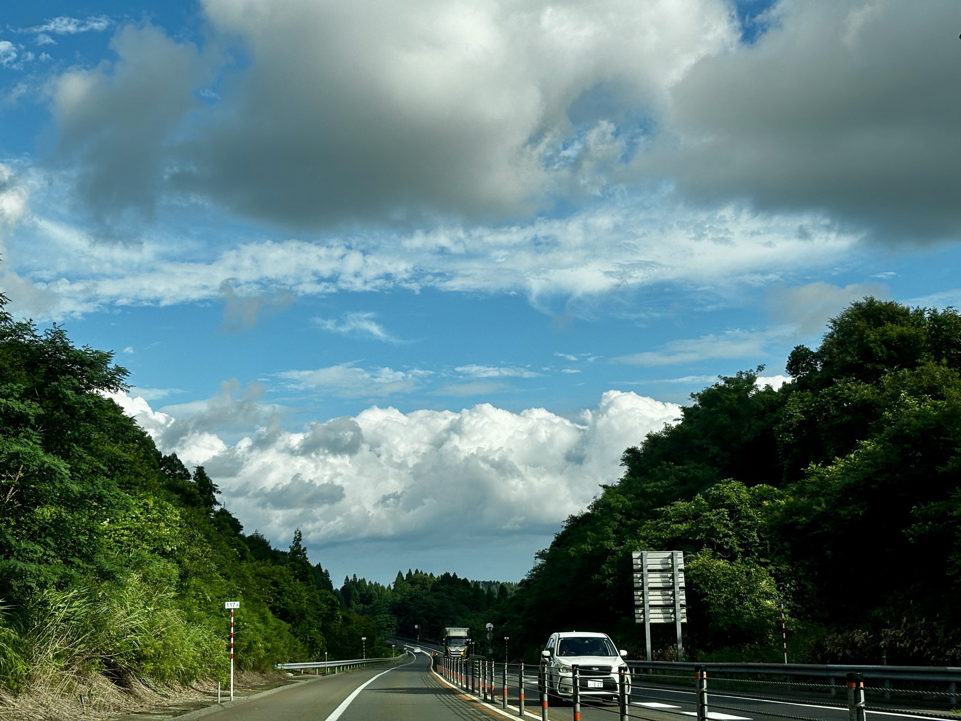
Akita Expressway cuts east to west through the mountains (photo by author).

Rice is the staple in Japan. But it is also more than just food, as the anthropologist Emiko Tierney Ohnuki explains in her book, Rice as Self: “As a metaphor of self, rice paddies are our ancestral land, our village, our region, and ultimately, our land, Japan. They also represent our pristine past before modernity and foreign influences contaminated it” (p. 10). Later she explains, “The notion that each rice grain has a soul and that rice is alive in the hull are fundamental to the meanings assigned to rice in Japanese culture…” (p. 55). The rice paddies prevail even as the countryside empties of people and the farming population ages. This phenomenon also explains the widespread resistance to foreign rice by Japanese consumers, even as rice prices have soared this year and been a major contributor to rising inflation.

Tohoku, with its relatively cold climate, has experienced several rice famines in the recorded history, many of them linked to natural disasters, such as cooling climate after volcanic eruptions. Latest in 1934, the rice crop in Iwate failed due to cold weather, causing many poor farm families to send their children to Tokyo and beyond as laborers, or to work in the water trade, or to join the military, all of which contributed to the pre-war unrest. In better times, Tohoku rice is arguably the best in the world, thanks to the clean environment and water.

Japan’s environmental history is at best checkered. The case of mercury poisoning in Minamata on the southwestern island of Kyushu starting in the late 1950s is perhaps the most famous incident of industrial pollution with dramatic consequences to people’s health. But there were plenty of others where the environment and human health were sacrificed to the altar of progress in post-war Japan, such as the Itai-Itai disease caused by cadmium poisoning discovered in 1967 or the PCB poisoning in and around Kitakyushu the year after. Opposition to industrial pollution was silenced, communities divided, and victims shunned, as the country focused on rebuilding and getting rich at any cost.

Since those years, much has been done to improve the environment. Environmental consciousness is high: practically no one litters, recycling is religiously practiced, and the cities are clean. Air and water pollution are now controlled. The largest urban conglomerations – Tokyo, Yokohama, Osaka, Kobe, Kyoto – are concentrated in the Central and Western Kanto and Kansai areas.

The Japanese culture has been largely based on the desire to control nature. This has its traditional expression in Japanese gardens in which nature has been forced into beautiful, but artificial depictions of, well, idealized nature. The tortured, but gorgeous bonsai trees are another example. For many Japanese, nature is at its most beautiful when it is well regimented.

Another factor playing into the tendency to control nature is the prevalence of natural hazards. Japan consists of a chain of volcanic islands in the middle of the largest ocean of the world, the Pacific. The country is prone to earthquakes that happen daily (although larger ones are of course rarer). Despite its name, the ocean frequently acts in ways anything but pacific, sending typhoons and tsunamis to the coasts. The eruption of the iconic volcano, Mt. Fuji, is long overdue. If a natural hazard exists, Japan is bound to have it in quantities. Consequently, Japan is also the best prepared nation towards natural hazards: even massive earthquakes tend to have relatively few victims.

There are exceptions, the most prominent one in recent history being the earthquake that hit Tohoku on the Pacific side on March 11, 2011. The 9.1 magnitude earthquake and the ensuing tsunami flattened out much of the Sanriku coastal zone in Miyagi and Iwate prefectures and killed almost 20,000 people. The tsunami also caused the meltdown of the Fukushima nuclear power plant resulting in the worst nuclear accident in human history, barring the Chernobyl accident in current-day Ukraine in 1986.

Up in in the mountains between Iwate and Akita, nature is largely unspoiled thanks to a low density of human population, little urbanization and even less industry. That in itself is largely the result of the mountainous topography, the harsh winters, and the relatively short growing season. Yet, virtually all flat valleys are under cultivation.

The topography is also what has saved Japan’s forests. This is one of the most forested countries in the world outside of the tropics, with 67% of land area covered in forests. Japan in the post-World War II years extensively replanted forests, with species like sugi and the Japanese cypress. According to environmental historian Catherine Knight, about 40% of Japan’s forests are currently man-made plantations, not naturally occurring ecosystems.

The forests would most certainly have been decimated had it been easier and more economical to exploit them. Instead, it is said that Japan has outsourced deforestation, especially to Southeast Asia where its companies have long maintained logging operations thereby saving the forests on the home islands.

What is evident even up here in Tohoku is the careful management of natural hazards and nature itself. Mountainsides where roads cross them are protected by engineering works to prevent landslides, which can be caused by earthquakes or just erosion of the slopes.

Japan has been referred to as the “construction state.” The Ministry of Construction and the numerous big and small companies operating in the sector wield significant power. They provide substantial employment and spend remarkable amounts of money as they fix the real and sometimes self-created problems.

In the decades following World War II, most rivers in Japan, notably near urban centers on the Kanto Plain, were straightened and channelized in concrete to control natural flow and meandering. Contrary to expectations, however, these works meant for flood control often had the opposite effect, while also harming ecosystems along the rivers. The government, to a degree, recognized the mistakes and mended its ways, leading the River Bureau of the Ministry of Land, Infrastructure, Transport and Tourism to reverse engineer riverine habitats since the 1990s. Today, Tohoku’s largest river – and to me the dearest – Kitakami-gawa flows quite freely from its origins at Mt. Nanashigure to the Pacific Ocean.

But the time of the construction follies is not over. Following the March 2011 earthquake and tsunami, which destroyed virtually all small fishing ports on the Sanriku coast, many survivors left. Especially younger people moved to Sendai and other cities. Few of the refugees had any intention to return to the coast. Given this and the fact that the tsunami threat will not disappear, to me the sensible thing would have been to develop the coastline to an area for nature and recreation. Instead, the government has invested tremendous amounts of resources to massive earth moving and construction works to raise the coastline, in the process destroying much of the nature literally flattening hills. This for a handful of mostly old people who may return. That just demonstrates the natural tendency of the authorities and the construction industry to find an engineering solution to any problem.

Driving through the central mountains, however, these problems are far away. Yet, just like Sanriku coast, the countryside in the remote sparsely populated areas is further emptying. Most of the young people have moved to cities and the small farmers have few heirs to take over their plots (although there is a small back-to-the-land movement driving some younger urbanites to a more organic lifestyle in the rural areas). One might think that depopulation might lead to rewilding of the land – a popular concept in some parts of Europe – and there may be some benefits to the wildlife. However, the traditional farming system – satoyama – is surprisingly well adapted to the natural ecosystem. The rice paddies themself are ecotopes of their own, with a vibrant fauna and flora. There are studies that suggest that losing this agricultural landscape is a threat to the biodiversity that has evolved in them.

Japan is making measurable progress on climate and environmental fronts and is rolling out a nature-positive economy strategy, which includes the “30 by 30” conservation target, aiming to protect 30% of land and marine regions by 2030. Yet, challenges remain, not least as global temperatures rise affecting climate and weather in this island nation.

Tohoku’s rugged landscapes remind us that Japan’s story is not just one of futuristic glory and control of the environment, but of coexistence with nature, which offers lessons in resilience and balance that Japan, and the world, will need more than ever.


Thursday, July 10, 2025

Is another massive tsunami imminent in Japan?

Fourteen years ago, Japan was devastated by one of the deadliest tsunamis in modern history. Now a prophetic manga is fueling anxiety of a repeat. Could such a calamity occur soon again?

On Friday, March 11, 2011, at 14:46 hrs, disaster struck Japan. One of the largest earthquakes—officially the Great East Japan Earthquake—on record (magnitude 9.0) occurred just off the northeast Pacific coast of the main island of Honshu. The shaking lasted for a full five minutes—a terrifyingly long time when one entirely loses orientation, may not be able to stand up, with everything falling around you, walls and houses crumbling, the rumble of the earth drowning all other sounds—triggering a massive tsunami. Because the epicenter was so close to the coast, there was hardly any warning or time to evacuate. The first waves reached the Sanriku coast in the Miyagi and Iwate Prefectures within ten minutes, completely overrunning the towns and ports leaving total destruction in their wake. Up to 18,500 people perished. The tsunami also caused the meltdown of the nuclear power plant in Fukushima, Miyagi Prefecture, the worst nuclear accident ever to hit Japan and the worst in the world only after Chernobyl.

Now some people, are again fearful to visit Japan. This is because of a manga comic, published in 1999 and re-released in 2021, warns of a catastrophe hitting Japan in July 2025. The only reason why this comic might scare people off is that it originally predicted, correctly it turned out, a major disaster in Japan in March 2011. The Future I Saw, by the artist Ryo Tatsuki, imagines a massive tsunami caused by a rupture in the undersea fault line between the Philippine and Eurasian plates. As a consequence, the number of tourists, especially from China and Hong Kong, has dropped significantly and some people have decided to postpone their trips to Japan. Tatsuki herself says that she is no prophet.

The scenario itself is not entirely unrealistic. Tsunamis are triggered by undersea events, most often large earthquakes at fault zones, but sometimes by volcanic eruptions or massive landslides deep in the ocean. The Pacific Rim where Japan is located is seismically highly active. The Sanriku Tsunami was the fifth most deadly in the past two centuries or so. The deadliest of all was the Indian Ocean Tsunami on Boxing Day of 2004 when an estimated 230,000-280,000 people perished in half a dozen countries surrounding the Indian Ocean. This was the second time the Sanriku coast was devastated by a tsunami: on June 15, 1896, another tsunami killed some 22,000 people in the same area with waves reaching the height of 30 meters.

Tsunamis are so deadly because of the massive amounts of water and the speed at which they travel. In deep water, the waves remain low but they spread fast in all directions from the epicenter. Tsunami waves have been measured to move at 800 km/h. As they approach shallower coastal waters they slow down, condense, and rise to frightening heights.

This is what destroyed so much of the Sanriku coast. Kesennuma, a port in Miyagi, was gone. I have visited the town both before and after the disaster. First the tsunami swept across the entire low-lying valley. When it receded, fires that ensued as gas pipelines were destroyed finished the job burning down the entire old wooden town. Kesennuma port had been the center of the Pacific shark fisheries just because of the shape of its natural harbor. Now this same geographic advantage had provided the tsunami with a perfect entrance to the harbor bowl allowing the water to rise unhindered into the town.

Tohoku’s largest city, Sendai, situated on higher ground and away from the sea was largely spared from major damage. The city airport closer to the coast was not so lucky. Cameras showed the massive wave sweeping slowly across the runways. Large jet planes floated away like toy models. Aerial shots from the close by mountain areas showed huge liquefaction of the soil, again in slow motion, wiping away entire villages, houses crumbling and washing down the slopes into the sea. 

So what are the chances that such a disaster repeats itself in the near future, if not later this month? It is impossible to give a precise answer to that question. Statistically, major tsunamis globally take place about twice in a decade. The likelihood of one striking a specific major urban is low but it is plausible that one of the major cities around the Pacific Ring of Fire will be struck by a large tsunami in the coming few decades.

The cities most at risk include the Tokyo-Yokohama conurbation, the largest city complex in the world with over 40 million inhabitants. This is also Japan’s economic heart, so a major disaster there would be highly destructive for the country and would disrupt the entire world economy.

Other likely targets include Manila and Jakarta on the Asian side, and Lima and Santiago de Chile in South America, as well as Los Angeles and San Francisco in California. Honolulu in the middle of the Ring of Fire is also vulnerable. In fact, all of these cities have in the past experienced disruptive earthquakes and tsunamis.

Indonesia and its capital Jakarta are particularly at risk from a repeat of an event like the 2004 earthquake and tsunami. Another risk is posed by the active volcano, Krakatoa. Its violent eruption caused a massive tsunami on August 27, 1883. It destroyed two-thirds of the island and killed some 36,000 people, making it the second deadliest event in recorded history.

Hawai’i due to its location has experienced three tsunamis claiming lives in the past eight decades. The worst one was on April 1, 1946, when a 8.6 magnitude earthquake in the Aleutian Islands sent a tsunami racing across the ocean. It destroyed most of Hilo on the Big Island, killing 159 people. As the earthquake that instigated the tsunami took place in Alaska thousands of kilometers northeast of Hawai’I, no one was prepared when the huge waves washed into the islands in the middle of the Pacific Ocean.

When the 9.5 magnitude—the strongest ever recorded—earthquake hit Chile on May 23, 1960, Hilo, 10,000 km away from the epicenter, was again collateral damage and 63 people died there (the range of the casualties overall varies significantly, from 1,000 to 6,000). On November 29, 1979, a local 7.7 magnitude earthquake shook the Big Island causing two deaths. Such a locally generated tsunami gives hardly any warning time for people to escape.

All of the cities exposed to high tsunami risk are constantly monitoring the situation. Japan, with its multi-hazard risk and frequent earthquakes (in fact, a 5.5 magnitude earthquake shook the southwestern Kagoshima Prefecture while I am writing this on the 3rd of July), is arguably the best prepared country in the world. In this, it is helped by its advanced technologies and well-educated, self-disciplined population. Japan employs a national earthquake and tsunami early warning system operated by the Japan Meteorological Agency. It informs people of impending danger through sirens and phone alerts. It has recently deployed drones on the sea in front of popular beaches for tsunami detection. Detailed evacuation maps are maintained by local governments down to the neighborhood level.

Furthermore, millions of people in the country participates in drills and education sessions. September 1st is the National Disaster Prevention Day, with the date commemorating the Great Kantō Earthquake that destroyed Tokyo in 1923.

Scientists in Japan give an 80 percent chance for a mega-quake taking place along the Nankai Trough in the coming 30 years. This revised assessment has led the authorities to require municipalities and businesses to enhance their preparedness plans, to strengthen building earthquake resistance, stockpile food and other necessities, and to update evacuation plans.

Earthquakes and tsunamis cannot be predicted with any degree of certainty. A major event is certain to cause significant damage to infrastructure and the economy. The death of thousands of people in such eventuality is unavoidable. The best we can do is to be aware of the risks and be well prepared. That is our best chance of saving lives.

[Originally published on https://juhauitto.substack.com on July 4, 2025.]

Saturday, August 31, 2024

Exploring Miyagi Wetlands


All photos by the author

The wind was blowing hard across the open flat space as we arrived at Izu-numa. All boats had been stranded and moored by the lakeside. This was a disappointment but understandable. I could see the bamboo thickets on the northern side of the lake bending in the wind while hawks soared above taking advantage of the lift provided by the airflow.

Izu-numa is one of the wetlands in Miyagi Prefecture of Japan, designated as a Ramsar Site. It’s located north of the prefectural capital of Sendai, which received some international fame during the 2011 earthquake and tsunami that killed thousands of people and led to a partial meltdown at the Fukushima nuclear plant. We had arrived from the opposite direction, from Oshu in Iwate Prefecture just some 100 km further north on the Japanese mainland. I was traveling with a small group of friends from Oshu in their van.


Instead of getting on a boat, we walked around the shore where the lake gave way, first, to a carpet of water lilies, then a brush of reeds growing in the soft, muddy soil. Some birds, including a couple of egrets with their wings shiny white under the summer sun, took of from the undergrowth as they detected our approaching steps. The whole landscape was deep green against a blue sky on which fluffy cumulus clouds traveled fast driven by the wind.

The lake, although shallow – 1.6 meters at its deepest point – is very rich in biodiversity. There are 40 fish species that have been identified in the lake. That is many more than in most freshwater lakes or ponds. Several of these fishes belong to the family of carps. The lake and the surrounding wetland is one of the most important wintering locations for birds, such as whooper swans, in Japan. It is estimated that 90 percent of the greater white-fronted geese traversing Japan stop at the lake. All of 236 bird species have been identified in the area. The wetland is also well-known for its insect life, especially that of dragonflies. For all these reasons, the Isu-numa – Uchi-numa wetland complex was the second in Japan to be designated a Ramsar site in 1985, just after the Kushiro wetlands in Hokkaido. Wetlands are among the most productive and biologically rich ecosystems in the world. As such, they are also essential for human well-being.

After spending time on the lake shores, we entered the well-equipped Sanctuary Center on a knoll just above the wetland. Operated by the Miyagi Prefectural Izunuma-Uchinuma Environmental Foundation, the modern building is designed to resemble a white swan spreading its wings. Despite its size, it fits well into the landscape, with large panoramic windows overlooking the natural area. The Foundation engages in conservation, information and research work. The exhibits in the two-story hall were very interesting. Luckily for me, there was a staff member who was delighted to explain some of it in fluent English to me.


The Ramsar Convention was adopted in 1971 and came into force in 1975. It is thus one of oldest modern international environmental agreements. Its official name is the Convention on Wetlands and it provides an international framework for the conservation and wise use of these productive landscapes that are extremely important for the preservation of biological diversity, water and other assets that are essential for the survival of our species. Ramsar is a city in Iran where the agreement was created. Since then, almost nine-tenths of the world’s countries have become “contracting parties” to the Convention. The United States has been a member since 1986 and boasts 41 Ramsar sites, ranging from the Aleutian Islands and Hawaii to all over the continental lower 48 states.

Japan joined in 1980 and has all of 53 Ramsar sites, again ranging from Hokkaido in the north to Okinawa in the south. Six of the sites are in the Tohoku region, which comprises the northern segment of the main island, Honshu. 


These include the Izu-numa and Uchi-numa National Wildlife Protection Area and Nature Protection Area covering 559 ha. Izu-numa and Uchi-numa are two interconnected freshwater lakes and their surrounding peat swamps in the In the Hasama River basin. Outside of the protected area, agriculture and especially rice cultivation prevails. The Hasama itself is a tributary of the Kitakamigawa, the largest river in northern Japan and one of my absolute favorites in the world, flowing from its origins at Mt. Nanashigure through Iwate and Miyagi prefectures until it reaches the Pacific Ocean. 

The two lakes and wetlands have extensive reed beds and are characterized by submerged vegetation, including water lilies. The alluvial plain is also one of the very few locations in Japan where wild rice grows, providing important nutrition to visiting waterfowl. Numerous species of Anatidae — ducks, geese, swans and related water birds — winter in the Izu-numa / Uchi-numa area. Already in 1967, the Government of Japan designated the area’s birdlife and habitat as a National Monument. One of the curiosities that demonstrates the closeness of the Japanese people and nation to nature is the designation of national soundscapes. In 1996, the call of the greater white-fronted goose (Anser albifrons) was selected as one of the 100 Soundscapes of Japan by the MInistry of Environment (in another blog, I mentioned that the wind chimes at Mizusawa train station are also designated as such). 

Current Ramsar-related research in the area focuses on the declining growth of wild rice and the wintering bird populations. Some of this research – and conservation action – is conducted by the Izunuma-Uchinuma Environmental Foundation, which engages in prevention of further shallowing of the lakes, eradication of harmful invasive species (like the largemouth bass), planting wild rice, and clearing excessive reed beds.


Leaving Izu-numa and its excellent information center, we circled the lake by its eastern end, exiting the nature protection area. Our next destination was Naga-numa, another shallow lake of similar size and oblong shape. It is located about 10 km southeast of Izu-numa and Uchi-numa in the town of Tome.  At the entrance to the lake there is a park, Naganuma Futopia Park, with its landmark Dutch windmill erected in 1991.

Luckily for us, the wind had abated and we were able to find a boater who would take us on the lake. We entered the small vessel covered with a canopy made of reeds. Even more than Izu-numa, Naga-numa was almost entirely covered by water lilies, except for two open water areas, in front of the small boat harbor and the center of the lake. The local boatman explained that this summer there were more water lilies than ever in the past decade.

Traversing the water lily beds, the boat gained speed entering the open water until we reached the other side of the lake where the lilies floated thick in a wide stretch. We lingered a good while, floating amongst the beautiful red flowers and large green leaves. The day was hot and sunny but there was a cooling breeze on the water. I felt very calm and satisfied with our outing in the beautiful and unique nature.

My friends taking a selfie among the Lotus


Monday, August 21, 2023

On the trains: America has a lot to learn from abroad


The train sped through the rice paddies that shone intense green in the bright sunshine. Some of the paddies seemed already be turning yellow, somewhat early for the season in the beginning of August. Behind the fields rose the Ōu mountain range that separates the central valley of Iwate from the Sanriku coast. It was a hot, clear day but thick white and black clouds were lingering over the mountains. We were heading north towards the highest peak in the range: Mt. Iwate that reaches 2,038 meters above sea level and is the tallest mountain in the northern part of Japan’s main island, Honshu.

This was a local train with just a few cars, with seats arranged on the sides facing the center aisle, subway style. We could see the conductor standing behind the glass in his cabin at the front of the train. Beyond him, we saw the tracks opening ahead of us. The train was quite crowded on this Sunday afternoon. High school kids, boys in soccer uniforms, old people dozing off, middle-aged women with shopping bags. Two pairs of young people were wearing beautiful cotton yukatas that looked cool in the hot afternoon. I was the only gaijin – foreigner – on the train, which we had caught at the station in Mizusawa, my wife’s hometown, about 70km south of the prefectural capital of Morioka. While we waited at the Mizusawa station, tens of nambu furin wind chimes provided a lovely soundtrack in the light breeze. The Japanese Ministry of Environment has designated Mizusawa station as one of the 100 Soundscapes of Japan.

The train ran smoothly, reaching high speeds between the stops. The stops were rather frequent: not just the bigger centers of Kitakami and Hanamaki, but numerous smaller places: Kanegasaki, Rokuhara, and others. A few passengers were traveling with suitcases, heading to the Hanamaki regional airport, which in addition to domestic airports serves international destinations in Taiwan and Shanghai. Due to the frequent stops, the trip to Morioka took over an hour. We could have taken the shinkansen bullet train, which would have been much faster – the elevated shinkansen tracks run more or less parallel to the local train tracks – but would then have missed the pleasure of slower travel at ground level. Traveling on these local trains in Japan is to me a distinct pleasure. It gives meaning to the tired old saying, attributed to Ralph Waldo Emerson: It’s not the destination. It’s the journey.

It is also such a joy to see that these local train lines are doing well and are in heavy use. They are carefully maintained and widely used by a variety of people. Apart from the bullet train and the local train line, there’s an superb highway – the Tohoku Expressway – that connects all these places. Yet, because of the excellent and affordable public transportation options, not that many people feel the need to jump into their own car. Consequently, the highway is not excessively crowded. Why bother driving yourself when you can just jump on a train and enjoy the scenery?

Despite my love for the local trains, I do appreciate the shinkansen as well. The bullet trains are, well, fast, smooth, reliable, and environmentally sound. It impresses me that the ride is so even that you can leave your drink unattended on the tray while the speed approaches or exceeds 300 km/h. The trains run so punctually that you can literally check your watch based on when the train departs. There is not even half a minute’s deviation from schedules (unlike in the US, where Amtrak staff only start thinking about getting the train ready a few minutes after the scheduled time). A couple of weeks ago we took the Yamabiko shinkansen from Tokyo to MizusawaEsashi, a trip of 500 km, which takes just over 2.5 hours.

Last April, I had the pleasure of taking the Nozomi shinkansen from Tokyo to Japan’s second city, Osaka, in the west of the country. That trip runs just below Mt. Fuji, Japan’s tallest at 3,776 meters. The iconic mountain boasts a perfectly symmetric cone rising close to the sea at Suruga Bay. Admiring the handsome landscape as we sped by it, I remembered years ago hiking to the top. It took several hours and, despite some additional oxygen, gave me a splitting headache. However, staying overnight on the summit was definitely worth it for the gorgeous sunrise over the Pacific Ocean. It’s easy to understand where Japan got its moniker as the Land of the Rising Sun.

These types of train are not the only ones in Japan. All major cities have functioning subways, and in many places – from Tokyo to Osaka to Naha in Okinawa – there are convenient and comfortable monorails running on elevated tracks connecting the cities to their airports. All rails in the country are, naturally, electrified, another major difference with the US. Of the Amtrak network, only the Northeast corridor, running from Washington, DC, to Boston, passing through Baltimore, Philadelphia and New York City, runs fully on electricity. The rest still relies on diesel and thus contributes to pollution and climate change.

The US situation is globally the exception. Countries from Europe to China have clean and efficient high-speed trains. As it happens, this year has allowed me to experience several of them. In May, I rode the Frecciarossa, which connects the north of Italy to the south, from Turin to Salerno. That train can reach even higher speeds, up to 360 km/h. I only took it from Rome to Florence to see a friend there. In July, while in Finland, I rode the intercity train from Helsinki to the second city of Tampere to visit another old friend. He had advised me to pay a few euro extra to reserve a seat on the second floor, which I did and could thus enjoy the scenery in quiet comfort (that is, until I descended to the restaurant car and joined a crowd of cheerful fellow travelers for a cold beer). The return to Helsinki was on an Italian-made Pendolino train, which is used in more than a dozen countries across Europe, as well as in China and some routes in the US.

Continuing from my native country to Switzerland, I landed in Zurich and had to travel to the capital, Bern, where I was to teach a three-day workshop hosted by the university. Naturally, I took the train. On the way back, there was an unfortunate delay due to an obstacle on the tracks, which forced the train to divert. The operators apologized profusely for the 6-minute delay in our arrival to Zurich.

This to me is the normal state of affairs. Virtually all developed countries have invested in high-speed electric rail networks. They are fast, safe, and environmentally sound. Only the US lags behind. Amtrak is losing money, with only the Northeast corridor operating on a profit. The ticket prices are exorbitant, making the train trip from, say, the national capital to New York City a luxury that is beyond the reach of many travelers. While the Acela trains would be capable of traveling at high speed, the state of the old rails prevents it from doing so, thus rendering the trip much slower than necessary – not to mention unreliable with frequent delays. As much of freight in the US moves by rail, the freight trains get the right of way, forcing the passenger trains wait for their passing.

Lack of basic services, such as reserved seats, even in business class, makes the boarding process into a mad rush, a deficiency that could so easily be remedied. (I do have to admit that there have been significant improvements to the boarding process at New York’s Penn Station, which I could experience early in the year.)

In addition, there are occasional derailments that give the perception that train travel is not safe. A recent poll showed that a majority of Americans think that traveling by private car is the safest mode of transportation, which obviously is far from truth, statistically. Still, derailments do happen and give Amtrak a bad rap. Recent ones include a derailment in Missouri in June 2022 and in Montana in September 2021, both of which resulted in loss of life. Add to that accidents, such as the February 2023 Ohio tanker train derailment in East Palestine close to the border to Pennsylvania, which spilled over 115,000 gallons of highly toxic and flammable vinyl chloride, it’s no wonder many Americans are suspicious of train traffic.

California, arguably the most progressive state in the union, has worked on a high-speed rail link between Los Angeles and San Francisco since the $33 billion project was approved in 2008. It was supposed to be completed in 2022, but is nowhere near there. The cost overruns are staggering. The latest estimates have placed the real cost to $113 billion. According to the New York Times, the difficulties have been mostly due to political compromises that have sent the tracks through various diversions through difficult, geologically complex, and costly routes in the mountainous and earthquake-prone area. With the costs escalating and the heavy delays holding back progress, political and public support to the project is flagging.

There are many explanations and excuses why rail traffic doesn’t catch on in USA. The above-mentioned difficulties with efficiency, cost, safety, and perceptions certainly all are important. There is also the issue of long distances. However, Europe is large, as well: it’s 3,300 km from Stockholm to Madrid, for example, or about the same distance as from Chicago to San Francisco. Distances in China are also long: about 2,300 km from Shanghai on the coast to Kunming in the Southwest. Americans take flying as a basic human right. But with the mess the airline traffic finds itself – frequent delays and cancelations, onerous security checks, crowded planes, poor service, unruly passengers – one would think that other alternatives would appeal to travelers. But for most people, the alternative that comes to mind is driving, even if it takes hours and sometimes days on crowded highways with aggressive drivers. Supposedly, this reflects the deep rooted individualistic on-the-road culture of Americans.

Then there’s the politics. In general, American politics from the Federal through State and local levels is highly contentious and polarized, making it hard to pass any major legislation involving costly investment. The general position, especially on the right, is that public investments – even as so much of infrastructure is crumbling – is unaffordable, as it would require raising the taxes for the rich. And, in particular, public transport smacks of socialism. In this atmosphere, making the needed investments for improving – and electrifying – the rail network would not be an easy task. The good news is that the $1.2 trillion Bipartisan Infrastructure Bill passed in 2021 does include $102 billion to improve rail infrastructure over the 2022-2026 fiscal years. It remains to be seen how far this will reach. But you have to start somewhere.